Historical Maps of Karachi
Download high-resolution versions of these maps: Historical Maps of Karachi [PDF, 4.9MB]
Download high-resolution versions of these maps: Historical Maps of Karachi [PDF, 4.9MB]


Content on this site remains the property of Arif Hasan, though it is free to use and distribute for both personal and commercial uses. However, any reproduction of the material made available here must be credited to its source, and if used online in any way, a link back to this site must be provided.

34 Comments
Hi
Is it possible to get a good quality resolution image of the 3rd map of Karachi ? i downloaded it but resolution isnt very clear . Need it as soon as possible for some work.
Thank you
Sonia Durrani
http://shehri.org/old%20karachi%20city%20maps.html
Thank you for uploading these treasures!
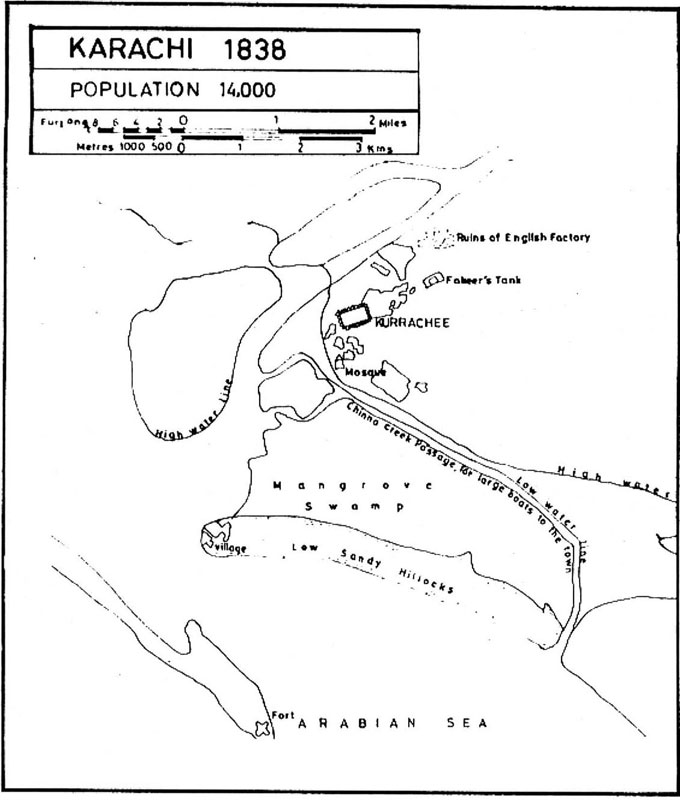
If we compare 1838 Map of Karachi Popoluation and 1838 Kurrachee Harbour Map. I guess Kurrachee is the most Autnetic name of the city in tose years.
Is the 1838 population Map genuine?
Rehan Hamid
Canada
hi my name is Rayan I am trying to locate my old grandparent’s house
In Garden East, it is possible that you can upload the map of Garden East Karachi, Pakistan. Before 1970
Hi Rayan,
You will be able to find them in the existing maps of Karachi.
Best Wishes,
Arif
I have an Karachi Guide map, published in 1947, at Surveyor General of Pakistan Office. The Map is printed in two colors i.e. red and purple, with reference list on its back side.
If anybody interested in this map, kindly contact at my above email address or below mentioned cell #
0332-3393979
Dear sir can u email me on the above mentioned email the detailed map of Karachi
AoA, Dear Nasir sahib,
I just called on the given cell number but could not connect. Can you kindly email me the Karachi Map you offered? I shall be grateful for this favour. Regards,
Adnan Ahmed Varaich, Faisalabad.
Email: aavaraich@gmail.com, Cell # 0333 7651188
Hello Nasir Sahib,
Wondering if you still have the collection of Karachi Map that you noted. I am most interested in receiving it by email Thank you. sajidaziz@rogers.com – Mississauga Ontario.
I am also particularly interested in the maps of Intelligence School which later became Intelligence Colony on Queens Road. Not far from where the new US Consulate is,
thank you for considering it
Sajid
Mr. Ahmed,
I would deeply appreciate a digital copy of this map. My mother did a fair bit of her growing up in Karachi, where her father was editor of The Daily Gazette. In trying to locate her childhood home, a map of the time would help her memory.
Thank you for your offer, even if you are not able to fulfil my request.
With warm regards from across the border…
Hello Sridhar,
I apologize for being so tardy, do you still need this?
Wishing your mother wellness and health,
Khadija I.
Arif Hasan Office
My name is Rayan I study maps Can you share with me the old map of Karachi Garden east? waiting for your reply sir
Hi Rayan,
You will be able to find them in the existing maps of Karachi.
Best Wishes,
Arif
Dear Sir Nasir There is no email of yours
cAN i HAVE THE OLD MAP OF kARACHI OF 19TH CENTURY WITH sPECIFIC REFERENCE TO THE BUNDAR ROAD ALONG WITH THE LOCATION OF THE kHARODAR AND MITHODAY AT THE TWO ENDS and the Keamari Port.
see my book karachi before the british conquest. you can get an e version at liittle book comany web site
Alir2d2@hotmail.com
Sir any area name Khadia compound nearby a theatre located
Could you be more specific? so that I can try and help you
My long lasting desire of looking at original Karachi, fulfilled today. Thanks Hasan Sain
Karachi served as the capital of Pakistan until 1960, when it was replaced by Islamabad. The Pakistani government believed the relocation of the capital would help spur development in the northern parts of the country. The map detail below, from a 1959 Army Map Service depiction, scaled at 1:250,000, shows the Karachi region in its final year as the national capital. Since this time, Karachi s population has boomed from about 2 million people in 1961 (in Karachi proper) to almost 15 million people today.
Can i get map of Liaqutabd town or and gulberg town or of whole karachi central? @khadija I.
Hello,
We will get back to you soon.
Khadija I.
Can you share me the old map of garden east,
Regards
Atlanta Georgia
Hi Mustafa,
You will be able to find them in the existing maps of Karachi.
Best Wishes,
Arif
Hello sir,
We are students and currently doing research on shahfaisal colony 1. Can I get the oldest map of shahfaisal colony which was previously known as drigh road muhajir colony please. Your cooperation will be highly appreciated. Thank you
Dear Mahnoor,
On my website, there are many maps. You can check them up for details about Shahfaisal colony.
Best wishes.
Dear Arif Hassan
Can you send me your web address?
My whatsapp # 0315-2858529
arifhasan.org
Dear Arif Hassan
Can you send me your web address?
My whatsapp # 0315-2858529
My web address is Arifhasan.org
I want lyari nawalane old map old survey no
Dear Hamza We do not have Lyari nawalane Maps